


‘The rise of placelessness, on top of the sense that the whole planet is now minutely known and surveilled, has given this dissatisfaction a radical edge, creating an appetite to find places that are off the map and that are somehow secret or at least have the power to surprise us.’ ― Alastair Bonnett (2014) ‘Off the Map’


During the autumn of 2017 I was exploring the notions of security and privacy and exploring whether borders and walls protect the citizens of our world. Who owns the liminal space that separates two different countries? What happens when we intersect pieces of land with borderlines?
I stumbled upon very different cases regarding borders between neighbouring countries, some of the toughest borders of the world, heavy militarized and guarded and even the complicated, yet peaceful, borderline between Belgium and Netherlands. The town of Baarle-Nassau has numerous small exclaves of Belgium, some of which contain counter-exclaves of the Netherlands and people cross freely multiple times a day. The immensely different case of the Darién Gap between Panama and Colombia consists of a 99 mile long and 31 mile wide gap of jungle that stands between the two countries. To prevent drug trafficking, there are no roads, only jungle. In contradiction to the border between Brazil and Bolivia, as seen from satellite images, where the results of Brazil’s illegal deforestation illustrate a massive distinction between the two countries.


In an attempt to map all existing and future walls, I read about their purpose, the reason behind their construction and how tough border crossings are. It was extremely disappointing to find that, due to the European refugee crisis of 2015, there are many new walls built and more are planned to be raised. Many of these walls will be virtual and monitored with drones, cameras, radar, boats, satellites and other high-end technology.
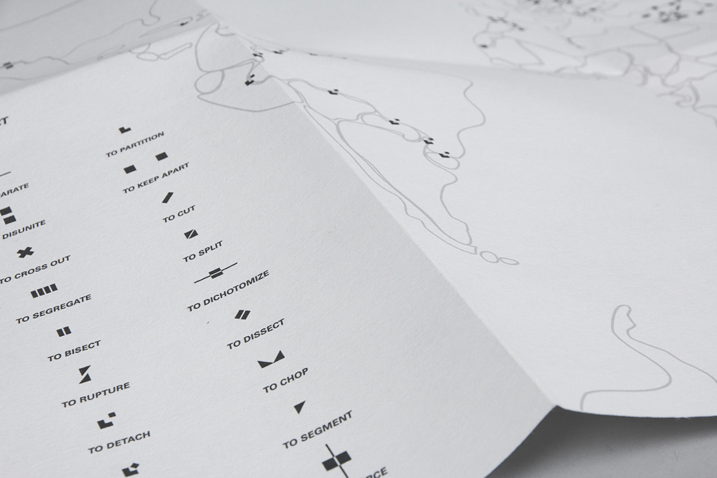
To analyze this matter, I created a list of words that indicate division (to separate, to segregate, to divide, to rupture, to dissociate, etc.) and their antonyms (to attach, to bind, to bridge, etc.) The meaning between the synonyms felt very similar at this point, in order to distinguish them, I started visualising them.
The initiative shape I used was a square, that I multiplied, subtracted or divided to created 64 mini-logos to illustrate my list of words and match the connotation each of these had in my mind.

With the intention to bring more context into my mini-logos, I created a world map with ambiguous border lines, and after analyzing the very diverse walls around the world, I placed the mini-logos according to the political situation between nations.
For example, Brazil began building walls on its border with Bolivia and Paraguay in 2007, and in 2013 it announced plans to secure the border with the rest of its 10 neighbors. It appears that Brazil is pursuing its detachment from the rest of South America, whereas, Norway, in response to an increasing number of migrants coming through its Arctic border with Russia, attempts to cut free movement by building an 11-foot-high steel fence. On the other hand, in 2015, Namibia said it wanted to electrify its border with Angola to prevent the spread of foot-and-mouth disease as well as lung disease in livestock and lets not forget, DMZ between North and South Korea. The Demilitarized Zone, one of the most famous border walls in the world, is 160 miles long and 2.5 miles wide and was established in 1953 under an agreement among North Korea, China and the United Nations, to indicate the rupture between the nations.
According to all different circumstances, I placed a corresponding mini-logo to describe, with one word, what the situation is like between all neighboring countries with walls raised between them.


To resemble the materiality of actual maps, The World Map of Conflict is printed on Paper Scroll Fabric, a non-woven poly based material constructed like latticework, the poly based fibres are layered, and then hook punched to bond them together. Unique qualities of the custom Scroll fabric are that it actually does not fray, does not crease; and is hard-wearing and untearable. It’s a light paper scroll material, made from recycled plastic bottles. It has a matt papery surface texture, and no elasticity, making it a very taut piece of material.


Throughout my research I came across unknown words (expediency, disfranchisement, lacuna) or words whose true meaning is much deeper than their actual meaning (identity, passport, no-man's land). I created a series of postcards with the dictionary meaning of each word on the back and the equivalent mini-logo on the front side of each postcard.


View Terra Australis Incognita to see the development of this research around borders, identity and typography.


