Bilbao Activity Center [Final Degree Project]
Luis M. Uriarte
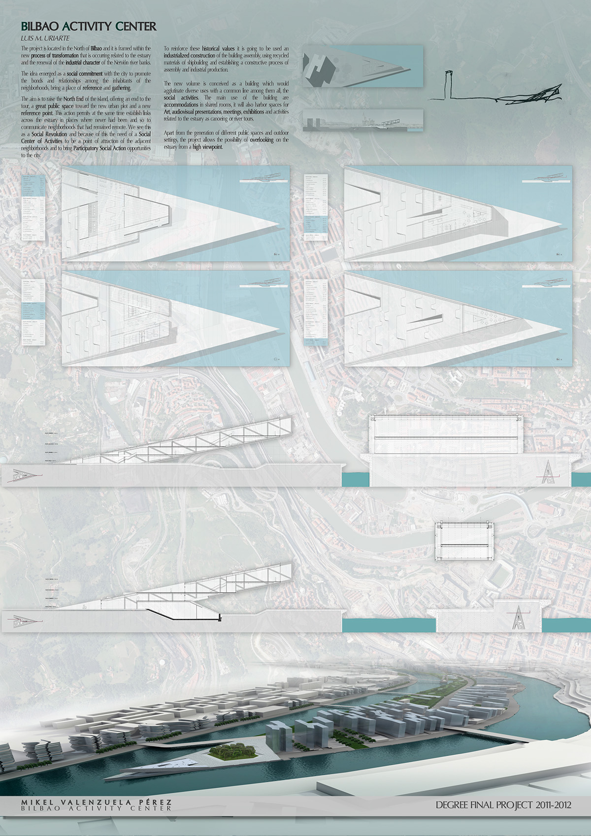
The project is located in the North of Bilbao and it is framed within the new process of transformation that is occurring related to the estuary and the renewal of the industrial character of the Nervión river banks.
The idea emerged as a social commitment with the city to promote the bonds andrelationships among the inhabitants of the neighborhoods, being a place of reference and gathering. The aim is to raise the North End of the island, offering an end to the tour, a great public space toward the new urbanplot and a new reference point. This action permits at the same time establish links acrossthe estuary in places where never had been and so to communicate neighborhoods that had remained remote. We see this as a Social Revolution and because of this the need of a Social Center of Activities to be a point of attraction of the adjacent neighborhoods and to bring ParticipatorySocial Action opportunities to the city.
To reinforce these historical values it is going to be used an industrialized construction of the building assembly, using recycled materials of shipbuilding and establishing a constructive process ofassembly and industrial production.
The new volume is conceived as a building which would agglutinate diverse uses with a common line among them all, the social activities. The main use of the building are accommodations in shared rooms, it will also harbor spaces for Art, audiovisualpresentations, meetings, exhibitions and activities related tothe estuary as canoeing or river tours. Apart from the generation of different public spacesand outdoor settings, the project allows the possibility of overlooking on the estuary from a high viewpoint.
El proyecto se sitúa en laparte norte de Bilbao y vieneenmarcado dentro del nuevo proceso detransformación que se ha ido produciendo, relacionado con la Ría y con la renovación del carácter industrial de las riberas del Nervión.
El proyecto surge como compromiso social con la ciudad para favorecer los nexos yrelaciones entre los habitantes de los barrios, siendo un lugar de referencia y agrupación.
Se pretende elevarel extremo Norte de la Isla, ofreciendo una finalización al recorrido, un gran espacio público hacia la nueva trama urbana y un punto dereferencia.
Esta actuación permite a su vez establecer nexos de unióntransversales a la Ría en lugares donde nunca los ha habido y poder comunicarbarrios que han permanecido aislados. Esto lo vemos como una Revolución Socialy por ello se entiende la necesidad de unCentro Social de Actividades que sea el foco de atracción de los barrioscolindantes y que pueda aportar al conjunto de la ciudad nuevas oportunidadesde Acción Social Participativa.
Para reforzar esos valores históricos se utiliza la construcción industrializada delmontaje del edificio, utilizando materiales reutilizados de la construcciónnaval y estableciendo un proceso constructivo de montaje y de producción industrializada.
El nuevo volumen se concibe como un edifico que aglutinaríadiversos usos con una línea común a todos ellos, las actividades sociales. Así, siendo el principal uso la el alojamiento en formato de habitacionescompartidas, también albergará espacios para el arte, la proyección de audiovisuales,reunión, exposición y de actividades relacionadas con la Ríacomo piragüismo o paseos fluviales.
Además de la generación de diferentes espacios públicos, tanto exteriorescomo cubiertos, el proyecto permite la posibilidad de asomarse sobre la Ría desde un puntode vista elevado.
Hotel for Professors on Campus
César Azcárate / Francisco Mangado
The site chosen is located within thecampus of the University of Navarra, surrounded by the Faculty of Theology and the garden maintenance building, located on a hillside.
Being a zone of the city with no urban plot relation and having as a reference only other faculties andcampus buildings, the ground contact will be fundamental in the situation. The project intends to use the land slope to build two longitudinal pieces at different heights and thus produce a minimal impact on the surrounding landscape. This sensitivity comes from the understanding of the place as a green and natural campus for the enjoyment of all.
The project consists in making a warm Hotel for guest lecturers from the University of Navarra. Its formal distribution is carried out through two different pieces; one would harbor areas for the service, installations, laundry andstorage room, and the other one would harbor the teachers’ rooms and common areas such as the pool, gym and dining room. In the space between the two pieces there would be an entrance lobby and the connection spaces and, finally, a third piece will be added on the top of the other two pieces: a windowed living room.

El solarelegido se sitúa dentro del Campus de laUniversidad de Navarra, enmarcado entre la Facultad de Teología y eledificio de mantenimiento de Jardinería, situados en una ladera. Al ser unazona de la ciudad no relacionada con la trama urbana y con el único referentedel resto de Facultades y edificios del Campus, el emplazamiento del edificio así como su contacto con el terreno serán fundamentales.
La propuesta pretende aprovechar lainclinación del terreno para construir dospiezas longitudinales a distintas alturas y así producir un mínimo impactoen el medio que le rodea. Esta sensibilidad nace del entendimiento del lugarcomo un campus verde y natural parael disfrute de todos.
El proyecto a realizar consiste enun acogedor Hotel para profesoresinvitados de la Universidad de Navarra y la distribución formal se realizamediante dos piezas diferenciadas que albergan, una los usos de servicios como instalaciones,lavandería y almacenes y la otra las habitacionesjunto con las zonas comunes comola piscina, el gimnasio y el comedor.
En el espacio intermedio de ambaspiezas se crea la entrada, el vestíbulo y los espacios de relación y finalmente se sitúa sobre ambas piezas el elemento añadido que es el salón acristalado, situado en la partesuperior.
Musical and Cultural center in Pamplona
César Azcárate / Carlos Puente
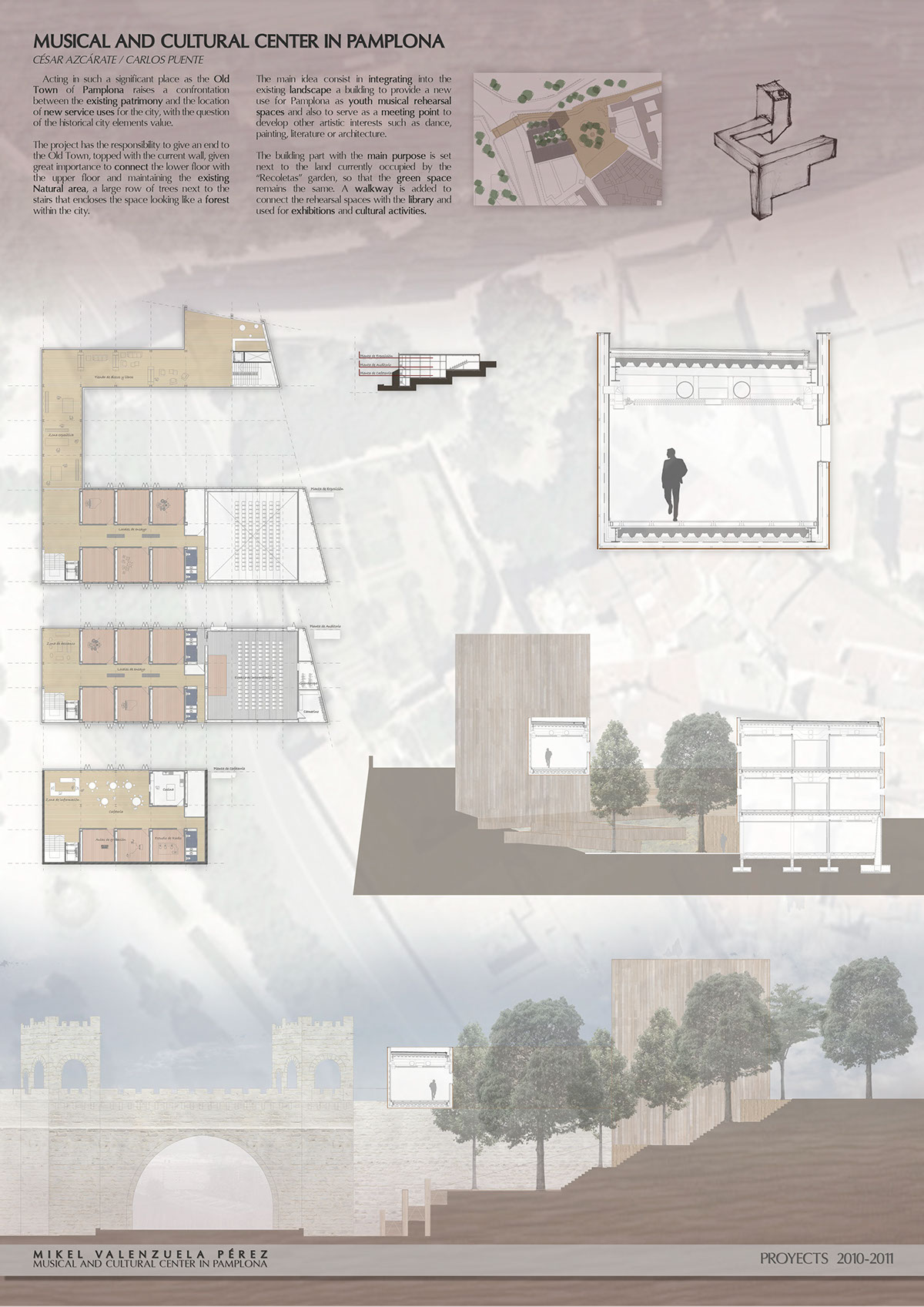
Acting in such a significant place as the Old Town of Pamplona raises a confrontation between the existing patrimony and the location of new service uses for the city, with the question of the historical city elements value.
The project has the responsibility to give an end to the Old Town, topped with the current wall, given great importance to connect the lower floor with the upper floor and maintaining the existing Natural area, a large row of trees next to the stairs that encloses the space looking like a forest within the city.
The main idea consist in integrating into the existing landscape a building to provide a new use for Pamplona as youth musical rehearsal spaces and also to serve as a meeting point to develop other artistic interests such as dance, painting, literatur e or architecture.
The building part with the main purpose is set next tothe land currently occupied by the “Recoletas” garden, so that the green spaceremains the same. A walkway is added to connect the rehearsal spaces with thelibrary and used for exhibitions and cultural activities.
La actuaciónen un lugar tan significativo como el CascoAntiguo de Pamplona hace que surja una confrontaciónentre el patrimonio existente yla ubicación de nuevos usos dotacionalespara la ciudad, con la reflexión de poner en valor los elementos históricos dela ciudad.
El solar tiene la responsabilidadde dar una finalización a un extremodel Casco Antiguo, rematado con lamuralla actual, dando gran importancia conectar la parte baja del solar con lasuperior y a su vez mantener el EspacioNatural existente; una serie de árboles de gran porte en hilera junto a laescalera que encierran el espacio pareciendo un bosque dentro de la ciudad.
La idea integrar en el paisajeexistente un edificio que aporte un nuevo uso para Pamplona como son locales de ensayos para jóvenes,sirviendo también como lugar deencuentro para desarrollar otras inquietudes artísticas como la danza, lapintura, la literatura o la arquitectura.
El bloque con el grueso delprograma se sitúa junto al terreno actualmente ocupado por el huerto de lasRecoletas, de forma que el espacio verdesiga siendo el mismo. A esto se le añade una pasarela que conecta los locales de ensayo con la biblioteca y que sirve para larealización de exposiciones y actividades complementarias.
Urban Development Plan in Azpilagaña
Rafael de Cáceres
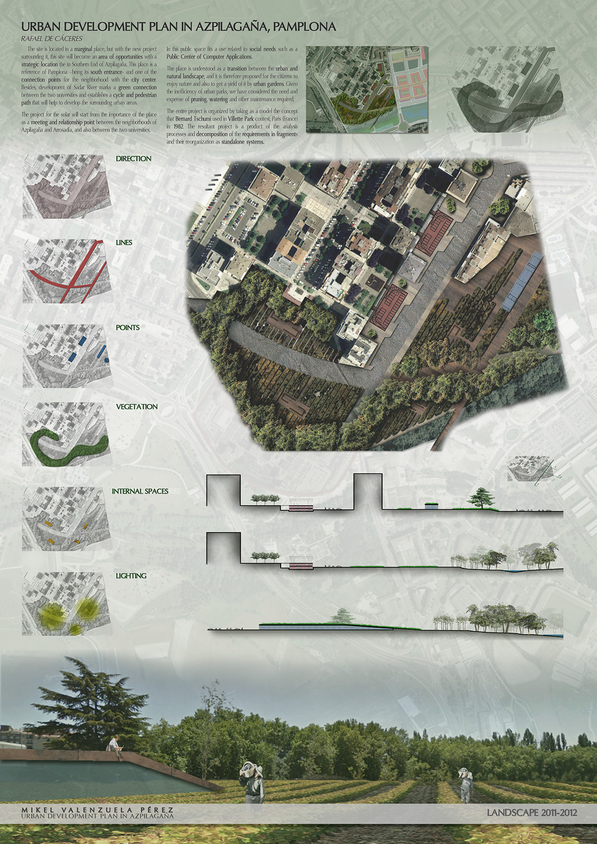
The site is located in a marginal place,but with the new project surrounding it, this site will become an area of opportunities with a strategic location the in Southern End of Azpilagaña. Thisplace is a reference of Pamplona –being its south entrance- and one of the connection points for the neighborhood with the city center. Besides, development of Sadar River marks a green connection between the two universities and establishes a cycle and pedestrian path that will help to develop the surrounding urban areas.
The project for the solar will start from the importance of the place as a meeting and relationship point between the neighborhoods of Azpilagaña and Arrosadía, and also between the two universities. In this public space fits a use related to social needs such as a Public Center of Computer Applications.
The place is understood as a transition between the urban and natural landscape, and it is therefore proposed for the citizens to enjoy nature and also to get a yield of it by urban gardens. Given the inefficiency of urban parks, we have considered the need and expense of pruning, watering and other maintenance required.
The entire project is organized by taking as a model the concept that Bernard Tschumi used in Villette Park contest, Paris (France) in 1982. The resultant project is a product of the analysis processes and decomposition of the requirements in fragments and their reorganization as standalone systems.
El solar se sitúa en un lugaractualmente marginal pero con las nuevas propuestas que lo rodean, pasará a serun lugar de oportunidad con unasituación estratégica de finalización del sur de Azpilagaña, siendo unreferente de Pamplona desde suentrada Sur y uno de los puntos de conexión del barrio con el centro de laciudad. Además el desarrollo del RíoSadar marca la conexión verde entrelas dos Universidades y establece un recorridopeatonal y ciclable que ayudará a desarrollar las zonas urbanas por dondediscurra.
La propuesta para el solar partiráde la importancia del lugar como puntode encuentro y relación entre los barrios de Azpilagaña y de Arrosadía, yentre las dos universidades. En este espacio público y de relación cabrá un usorelacionado con las necesidades sociales como puede ser el Centro Público de Aplicaciones Informáticas.
El lugar se entiende como una transición entre lo urbano y lo natural,y por ello se propone que los ciudadanos puedan disfrutar de la naturaleza y, asu vez, obtener un rendimiento de ella en forma de Huertas Urbanas. Teniendo en cuenta la ineficiencia de los parquesurbanos, nos planteamos la necesidad y el gasto que supone la poda, el riego ylos demás mantenimientos necesarios.
Se organiza toda la propuestatomando como modelo el concepto que utilizo Bernad Tschumi en el concurso del Parc de la Villette, París (Francia) en 1982, por lo que elproyecto resultante es producto de procesos del análisis y descomposición delprograma en fragmentos y su reorganización como sistemas autónomos.
Urban Development Plan in Vitoria
Eduardo Rojo
The creation of a Boulevard parallel tothe road is proposed with the aim of connecting the area with the rest ofVitoria through Madrid Street and, by doing so, favoring pedestrian and bicycletraffic and providing a space for a public transport such as the tram.
This boulevard will be raised up to the level of Arananeighborhood, above the road, allowing high connections and avoiding it frombecoming a physical barrier. This road elevation will be used to create privateparking for residents and releasing the outside space from vehicles.
To solve current green spaces defragmentation we seek forthe unity around Arana Park by connecting it with the vial with two flyovers,one through Galicia Street with the center of the city and the other onethrough the “Camino de Santiago”. The current park is slightly modified withthe intention of using it as a water debugging system.

Se proponela creación de un Boulevard paraleloa la autovía consiguiendo unir la zona con el resto de Vitoria a través de lacalle Madrid favoreciendo el tránsitopeatonal, de bicicletas yaportando un espacio para un transportepúblico como el tranvía.
Dicho boulevard se elevahasta alcanzar la cota del barrio de Arana y así estar por encima del vial,permitiendo pasos elevados deconexión y evitando que se convierta en una frontera física. Esta elevación del vial se aprovecha para crear aparcamientos privados para losresidentes de la zona liberando el espacio exterior de vehículos.
Para solucionar la actual desfragmentación de espacios verdes sebusca la unidad en torno al Parque de Arana, conectando éste con el vial pormedio de dos pasos elevados, uno a través de la calle Galicia con el centro dela ciudad y el otro a través del Caminode Santiago. El actual parque se modifica levemente con la intención deutilizarlo como sistema depuración delas aguas.
Vineyard in San Cristóbal
María Larrañeta
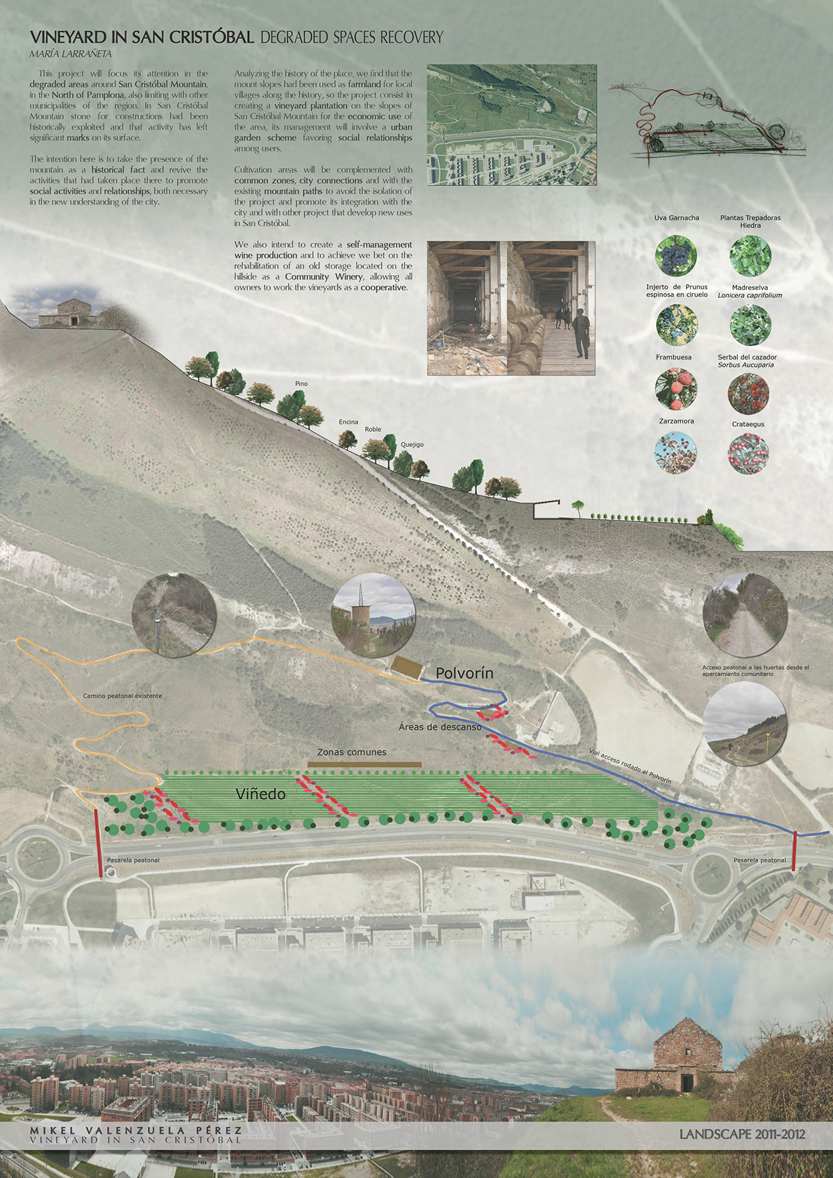
This project will focus its attention inthe degraded areas around San Cristóbal Mountain, in the North of Pamplona,also limiting with other municipalities of the region. In San CristóbalMountain stone for constructions had been historically exploited and that activity has left significant marks on its surface.
The intention here is to take the presence of themountain as a historical fact and revive the activities that had taken placethere to promote social activities and relationships, both necessary in the new understanding of the city.
Analyzing the history of the place, we find that the mount slopes had been used as farmland for local villages along the history, sothe project consist in creating a vineyard plantation on the slopes of San Cristóbal Mountain for the economic use of the area, its management wil linvolve a urban garden scheme favoring social relationships among users. Cultivation areas will be complemented with common zones, city connections and with the existing mountain paths to avoid the isolation of the project and promote its integration with the city and with other project that develop new uses in SanCristóbal.
We also intend to create a self-management wine production and to achieve we bet on the rehabilitation of an old storage located on the hillside as a Community Winery, allowing all owners to work the vineyards as a cooperative.
En este trabajose abordarán los espacios degradadosen torno al monte San Cristóbal, al norte de Pamplona y limitando también conotros municipios de la comarca. El monte San Cristóbal ha sido explotadohistóricamente en la extracción depiedra para las construcciones de la zona y esa actividad ha dejado unasmarcas importantes en su superficie.
La intención en este caso es la deabordar la presencia del monte como un hecho histórico y revivir las actividades que en él se han producidopara favorecer actividades socialesy de relación necesarias en el nuevo entendimiento de la ciudad.
En el análisis de la historia dellugar, nos encontramos con que las laderas del monte han sido utilizadas como campos de cultivo para los pueblos dela zona a lo largo de la historia, por lo que la propuesta se basa en crear unaplantación de viñedo en las faldasdel monte San Cristóbal para el aprovechamiento económico de la zona, pero a suvez entendidas en su gestión como HuertasUrbanas favoreciendo la relaciónsocial entre los usuarios. Para ello se complementará el cultivo con zonas comunes y conexiones con laciudad y con el resto de senderos del monte, para evitar el aislamiento de lapropuesta y fomentar su integración con la ciudad y con el resto de propuestasque desarrollen nuevos usos en San Cristóbal.
De otra manera se pretende crearuna autogestión en la producción delvino y, para conseguirlo, se apuesta por la rehabilitación del polvorín situado encima de la ladera como bodega comunitaria de producción, loque permite funcionar a todos los propietarios de los viñedos como unacooperativa.
Donapea Masterplan, Pamplona
José Mª Ordeig
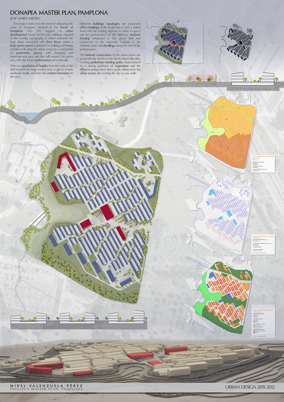
The project starts from the need of urbanizing the zone of Donapea, situated in the South of Pamplona City. Wesuggest an urban development based on low-rise buildings adapted to the existing topography, in which outstands the large slope associated with Elorz River,where a large green space is planned for walking and leisure activitiesfollowing the urban scene by a succession of pedestrian spaces with shopping andentertainment uses, and that will connect the green area with the future performance of Cordovilla.
Different buildings typologies are proposed: officebuildings at the South End to form a united front with the existing highway in order to space out the performance of this highway; students housing integratedin the green belt and connected to the university Campus in the northern solar;and dwellings along the rest of the performance. There is a gradation of heights from the ends of the field towards the large central area, to give it amore moderate scale, and from the eastern boundary to the river.
The Internal connections of the urban scene are perpendicular streets to the blocks lineal direction, creating pedestrian winding paths, characterized by a strong presence of vegetation and the different perspectives that can be observed in the urban scene, discovering the city as you walk.
El proyectoparte de la necesidad de urbanizar la zona de Donapea, situada al sur de la ciudad de Pamplona. Se plantea un desarrollourbanístico basado en edificaciones debaja altura adaptándose a la topografíaexistente, en la que destaca el gran desnivel asociado al río Elorz, donde seplantea un gran espacio verde de paseo yocio que continua en el tejido urbano mediante una sucesión de espaciospeatonales que aglutinan los usos dotacionales, comerciales y de ocio yposibilita la conexión de la zona verde con la futura actuación de Cordovilla.
Se plantean diferentes tipologías edificatorias: edificios de oficinas en el extremosur, para formar un frente respecto de la autovía existente que distancie laactuación de ella; viviendas paraestudiantes, integradas en la zona verde y relacionadas con el campusuniversitario en la zona norte del solar; y viviendas en hilera en el resto de la actuación. Se produce unagradación de alturas desde los extremos del ámbito hacia el gran espaciocentral, para dotarlo de una escala más asequible, y desde el límite Este haciael río.
Las conexiones interiores del tejido urbano son transversales a ladirección lineal de los bloques, creándose recorridossinuosos fundamentalmente peatonales,caracterizados por una importante presencia de vegetación y las diferentes perspectivas que se pueden observar dela trama urbana, descubriéndose la ciudad a medida que se transita.


