URBAN TOPOGRAPHIC ELEVATION: CHAPINERO
three-dimensional modeling of the topography and urban context of a sector in bogotá using grasshopper
The images below are samples of a personal and experimental exercise in which it was intended to model a small sample of Chapinero’s neighborhood in the city of Bogotá. Having as a starting point a Satellite Reference Map and IDECA’s (whose acronyms correspond to Spatial Data Infrastructure for Capital Territory in Spanish) geographical database, the Rhinoceros program with its plug-in Grasshopper were used to make a simultaneous three-dimensional lifting of the sector’s topography and constructions.

This in order to integrate different knowledge and disciplines, and to take advantage of software tools to develop urban mappings that ease the analysis and research processes. The result is a visual synthesis which summarizes a large amount of information and data, that are now understood from a spatial perspective, where the three-dimensionality of space is of utmost importance to understand the relationships between the factors.
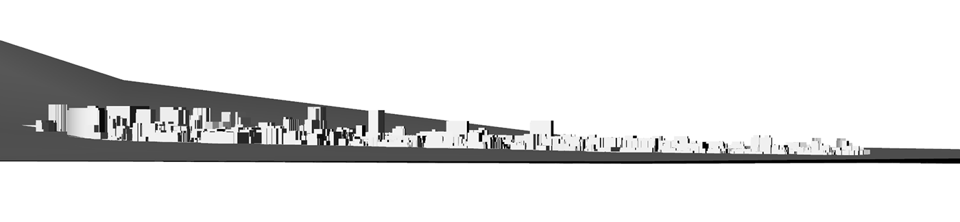
Thus, the relationship of the existing constructions between them and their environment was studied, as well as the urban profile of the sector, what geographical factors influence the urban layout, among others. All this integrating different systems such as GIS (Geographic Information System) and the visual programming language based on algorithms, as is the case with the Grasshopper interface. For the purposes of this exercise, it was essential to understand the analysis from a broad perspective, involving different disciplines (geography, anthropology, architecture, etc.), and work tools that complement each other, going from books to the latest digital trends.


